
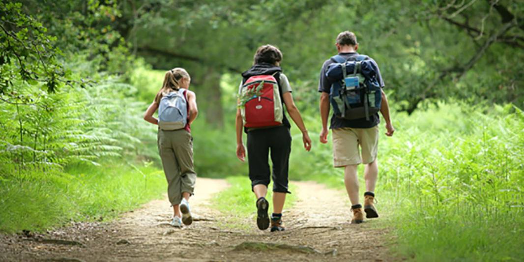
Recommendations for hiking
Recommendations for hiking
RECOMMENDATIONS FOR THE PRACTICE OF HIKING AND OTHER ACTIVITIES IN THE NATURAL ENVIRONMENT
- It is advisable to let your family or friends know the exact route you are going to take and its approximate duration
- Calculate the time it will take you to complete the route and avoid nightfall
- If you go in a group you should not separate from it to avoid getting lost
- Pay attention to signs and terrain features to use as reference points in case of loss
- Do not leave the marked trails to avoid the deterioration of the natural environment
- Wear comfortable and appropriate clothing and shoes for walking in the mountains, and according to the weather conditions
- Always carry enough water and wear a cap, sunglasses and sunscreen
- Do not uproot plants, you can end some protected species
- Do not smoke or use glass containers to avoid the risk of fire
- Respect and take care of rivers, fountains and other watercourses
- Always take the generated rubbish, including organic
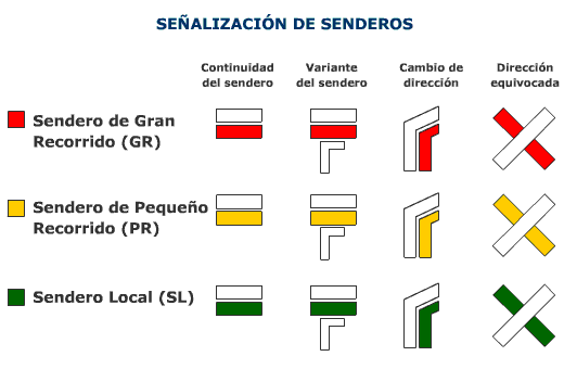
SIGNALING OF APPROVED PATHS
An approved trail is a sports facility identified by the registered trademarks of GR, PR or SL, which takes place preferably in the natural environment and on traditional roads, and which is approved by the corresponding regional and/or territorial federation.
Its characteristics must enable its use by the majority of users and throughout the year, and may be regulated for environmental and/or safety reasons. The approved trail is an integral part of a network of local, regional, and/or regional trails because it meets precise layout and signaling requirements.
The objectives of the approved trails are:
- Make it easier for the user to practice hiking, preferably in rural areas, providing safety, quality and information about the activity to be carried out.
- Encourage knowledge of the natural environment and the elements of the rural tradition of the spaces through which one travels, seeking a respectful, cultural and environmental practice.
Signaling and types of trails
The federative trail markings that are used belong to the so-called "Latin group" where those of Portugal, France, Italy, Luxembourg, Belgium and the Netherlands are included, with great similarity between all of them.
- Long Distance Trails (GR). They are routes or paths of more than 50 kilometers that are carried out in more than one day. There are also some routes with less than 50 kms marked as GR. The marks are white and red and their lettering is GR and a number corresponding to a national series.
- Short Route Trails (PR). They are routes or paths with more than 10 kilometers and less than 50, which can be done in one day. The marks are white and yellow and their labeling is PR followed by the territorial code (A for Andalusia) and the numerical code that identifies the route. These trails may have associated variants, derivations and links.
- Local Trails (SL). They are local trails or routes with less than 10 kilometers of distance. The marks are white and green and their labeling is SL followed by the numerical code that identifies the route within a territory (A for Andalusia).
- The variants. They are paths that start and come together in the same path at two different points. The variants will be marked as the path from which they start and denominated by correlative numbers.
- The referrals. They are stretches, always signposted, that start from an approved GR or PR and link the trails with nearby elements of interest. They always imply that the round trip from and to the main path will be along the same path. They will always have the same signs as the main path or the variants, but they will never have signs with the same labeling.
- The links. They are trails that join others, two of the same or different rank.